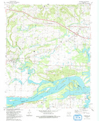
1993 Map of Hartman
USGS Topo · Published 1993About this map
Hartman serves as a focal point in this 1990s-era landscape, where the northern shore of Lake Dardanelle meets the agricultural and industrial interior of Johnson County. The map documents a complex infrastructure of levees and gas fields, with a Mine Dump near Hoyt and Montana indicating the region's extractive history. Transportation patterns are defined by the Arkansas River and an Old Railroad Grade that cuts through the southern reaches near New Spadra. Local history is preserved in several small settlements and religious landmarks, including Union Grove Ch and Sacred Heart. Across the water, Morrison Bluff sits on the southern bank in Logan County, connected by the river's wider flow around Skaggs Island. The presence of numerous cemeteries like Garrett Cem and Spadra Cem provides significant data points for genealogical research in this river valley setting.
Find a feature on this map
38 named features on this map. Tap any name to fly to it.
Don’t see what you’re looking for? This feature index may not catch every label — zoom into the map to look around manually.
Map Details
Editions of this 1993 Hartman Map
This is the sole edition of this map. No revisions or reprints were ever made.
Other maps of this area

1887 · Magazine Mountain #1
USGS Topo · 1:62,500

1887 · Magazine Mountain
USGS Topo · 1:62,500

1888 · Dardanelle #2
USGS Topo · 1:62,500

1889 · Ozone
USGS Topo · 1:62,500

1890 · Magazine Mountain
USGS Topo · 1:125,000

1890 · Dardanelle
USGS Topo · 1:125,000

1906 · Batson
USGS Topo · 1:62,500

1934 · Ozone
USGS Topo · 1:62,500

1936 · Ozone
USGS Topo · 1:62,500

1956 · Russellville
USGS Topo · 1:250,000