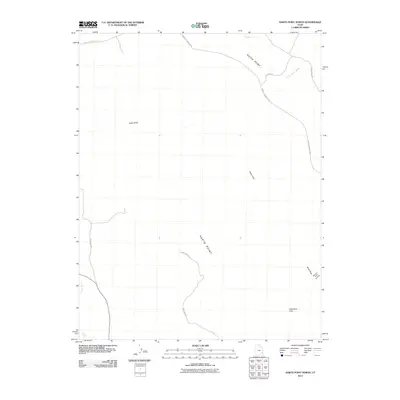
2011 Map of Harts Point North
USGS Topo · Published 2011About this map
Harts Point and the adjacent Hatch Point define this high-plateau landscape in San Juan County, where deep drainages like Harts Draw cut through the high desert. The terrain is marked by significant natural landmarks, most notably the Aqueduct Arch in the southeast and the steep descent into Bobbys Hole Canyon. This 2011 survey details a network of primitive and local routes, including the Needles Overlook Rd and Hart Point Rd, which provide access across the mesas. Water is scarce in this environment, represented by the ephemeral courses of Threemile Creek and Little Water Creek to the north, and Indian Creek as it winds through the southwestern corner. The mapping of these roads and natural features provides essential context for those studying the land use and geomorphology of this specific section of the Utah desert.
Find a feature on this map
13 named features on this map. Tap any name to fly to it.
Don’t see what you’re looking for? This feature index may not catch every label — zoom into the map to look around manually.
Map Details
Editions of this 2011 Harts Point North Map
This is the sole edition of this map. No revisions or reprints were ever made.
Other maps of this area

1885 · La Sal
USGS Topo · 1:250,000

1954 · Carlisle 4 SW
USGS Topo · 1:24,000

1954 · Mt Peale 3 NW
USGS Topo · 1:24,000

1954 · Mt Peale 3 SW
USGS Topo · 1:24,000

1954 · Mt Peale 2 SW
USGS Topo · 1:24,000

1954 · Carlisle 4 NW
USGS Topo · 1:24,000
1954 · Carlisle 4 SE
USGS Topo · 1:24,000

1954 · Carlisle 1 SE
USGS Topo · 1:24,000

1954 · Carlisle 4 NE
USGS Topo · 1:24,000

1954 · Carlisle 1 SW
USGS Topo · 1:24,000