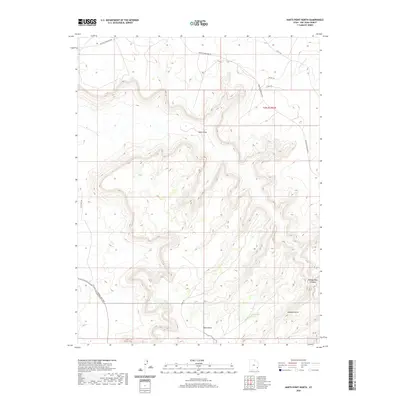
2020 Map of Harts Point North
USGS Topo · Published 2020About this map
Harts Point dominates the southern landscape of this 2020 San Juan County survey, where the high mesa breaks into complex drainage systems. The terrain is defined by dramatic erosional features, most notably Bobbys Hole Canyon and the distinctive Aqueduct Arch to the southeast. Water management and natural flow are traced through Harts Draw, which bisects the center of the sheet, and the perennial-style markings of Little Water Cr in the northeast corner.
Find a feature on this map
14 named features on this map. Tap any name to fly to it.
Don’t see what you’re looking for? This feature index may not catch every label — zoom into the map to look around manually.
Map Details
Editions of this 2020 Harts Point North Map
This is the sole edition of this map. No revisions or reprints were ever made.
Other maps of this area

1885 · La Sal
USGS Topo · 1:250,000

1954 · Carlisle 4 SW
USGS Topo · 1:24,000

1954 · Mt Peale 3 NW
USGS Topo · 1:24,000

1954 · Mt Peale 3 SW
USGS Topo · 1:24,000

1954 · Mt Peale 2 SW
USGS Topo · 1:24,000

1954 · Carlisle 4 NW
USGS Topo · 1:24,000
1954 · Carlisle 4 SE
USGS Topo · 1:24,000

1954 · Carlisle 1 SE
USGS Topo · 1:24,000

1954 · Carlisle 4 NE
USGS Topo · 1:24,000

1954 · Carlisle 1 SW
USGS Topo · 1:24,000