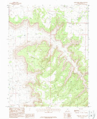
1987 Map of Harts Point North
USGS Topo · Published 1987About this map
Harts Point and Hatch Point dominate this high desert landscape, characterized by dramatic plateaus and winding drainage systems in San Juan County. Compiled from early 1980s aerial photography, this survey documents the isolation of the region through its sparse human interventions. Evidence of exploration and resource extraction is scattered across the terrain, notably at several prospect sites and a Barrow Pit near the northern boundary. The intricate network of canyons and washes is defined by Indian Creek and Harts Draw, which carve deep into the plateau floor. A notable geological feature, the Natural Bridge, is marked in the southeastern corner, serving as a landmark for those navigating by 4wd tracks or trail. The presence of ephemeral water sources like Threemile Creek and Little Water Creek highlights the hydrology of this arid canyon country.
Find a feature on this map
12 named features on this map. Tap any name to fly to it.
Don’t see what you’re looking for? This feature index may not catch every label — zoom into the map to look around manually.
Map Details
Editions of this 1987 Harts Point North Map
This is the sole edition of this map. No revisions or reprints were ever made.
Other maps of this area

1885 · La Sal
USGS Topo · 1:250,000

1954 · Carlisle 4 SW
USGS Topo · 1:24,000

1954 · Mt Peale 3 NW
USGS Topo · 1:24,000

1954 · Mt Peale 3 SW
USGS Topo · 1:24,000

1954 · Mt Peale 2 SW
USGS Topo · 1:24,000

1954 · Carlisle 4 NW
USGS Topo · 1:24,000
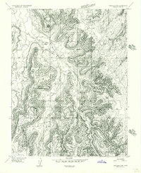
1954 · Carlisle 4 SE
USGS Topo · 1:24,000

1954 · Carlisle 1 SE
USGS Topo · 1:24,000

1954 · Carlisle 4 NE
USGS Topo · 1:24,000

1954 · Carlisle 1 SW
USGS Topo · 1:24,000