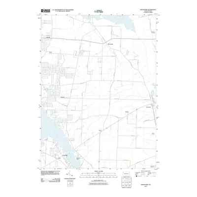
2010 Map of Hartstown
USGS Topo · Published 2010About this map
Pymatuning Reservoir and the Shenango River dominate the western edge of this landscape, framing a region defined by its small crossroads settlements and agricultural grid. The map details a network of rural communities, from the lakeside cluster of Espyville in the northwest to the established town of Hartstown in the southeast. This document preserves the locations of numerous family-named landmarks and local burial grounds, including the Willson Cemetery and Patton Cemetery, which serve as vital points of reference for genealogists. The land is drained by waterways like Bennett Run and Patton Run, which cut through the terrain toward the reservoir. Cultural features such as the Hartstown Golf Course and nearby State Game Lands reflect the area's transition into a space for recreation and conservation alongside its traditional rural character.
Find a feature on this map
62 named features on this map. Tap any name to fly to it.
Don’t see what you’re looking for? This feature index may not catch every label — zoom into the map to look around manually.
Map Details
Editions of this 2010 Hartstown Map
This is the sole edition of this map. No revisions or reprints were ever made.
Other maps of this area

1905 · Andover
USGS Topo · 1:48,000

1906 · Linesville
USGS Topo · 1:62,500

1907 · Andover
USGS Topo · 1:62,500

1907 · Kinsman
USGS Topo · 1:62,500

1908 · Shenango
USGS Topo · 1:62,500

1908 · Linesville
USGS Topo · 1:62,500

1950 · Cleveland
USGS Topo · 1:250,000

1956 · Cleveland
USGS Topo · 1:250,000

1958 · Greensville West
USGS Topo · 1:24,000
1958 · Greensville East
USGS Topo · 1:24,000
Featured Places
- North Shenango Township, PA
- South Shenango Township, PA
- West Shenango Township, PA
- West Fallowfield Township, PA
- Westford, Pymatuning Central