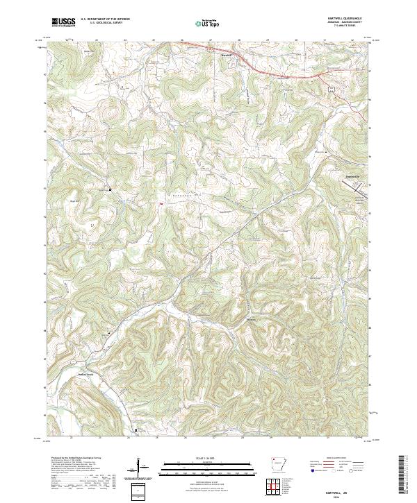
2024 Map of Hartwell
USGS Topo · Published 2024About this map
Hartwell and the surrounding Ozark foothills of Madison County are defined by a complex network of ridges and deep hollows. High points such as Bohannan Mtn and Boyd Mtn separate the drainage basins of numerous winding waterways, including Hock Creek, Holman Creek, and Glade Creek. The settlement pattern follows these natural corridors, with clusters of family history preserved in remote locations like Farmer Cem, Worley Cem, and Neal Cem. To the east, Huntsville serves as a local hub, anchored by the Huntsville Municipal Airport. The landscape is a maze of county roads, such as Madison 7500 and Old Hwy 68, which connect isolated communities like Roxton and Drakes Creek through terrain marked by deep features like Hartwell Hollow and Mantie Hollow.
Find a feature on this map
92 named features on this map. Tap any name to fly to it.
Don’t see what you’re looking for? This feature index may not catch every label — zoom into the map to look around manually.
Map Details
Editions of this 2024 Hartwell Map
This is the sole edition of this map. No revisions or reprints were ever made.
Other maps of this area

1900 · Eureka Springs
USGS Topo · 1:125,000

1901 · Eureka Springs
USGS Topo · 1:125,000

1943 · St. Paul
USGS Topo · 1:62,500

1945 · Harrison
USGS Topo · 1:250,000

1946 · St. Paul
USGS Topo · 1:62,500

1949 · Harrison
USGS Topo · 1:250,000

1954 · Harrison
USGS Topo · 1:250,000

1956 · Russellville
USGS Topo · 1:250,000
1958 · Goshen
USGS Topo · 1:24,000
1958 · Spring Valley
USGS Topo · 1:24,000