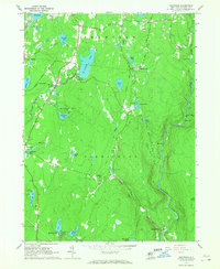
1966 Map of Hartwood
USGS Topo · Published 1967About this map
Forestburg and the surrounding townships of Thompson and Forestburg are defined by a complex network of glacial ponds and watercourses during the mid-1960s. The Neversink River cuts through the eastern edge of the quadrangle, joined by tributaries like Bush Kill and Eden Brook. This era shows a landscape transitioning from traditional rural life toward recreational and institutional land use, evidenced by the private Hartwood Club, Camp Forestburg, and the Fish Hatchery near Philwold. Significant local landmarks include the St Thomas Cem and the various clusters of dwellings at Oakland Valley and Squirrels Corners. An Old Railroad Grade remains visible near Melody Lake, tracing the path of former commerce through the wooded hills. The map captures many small water bodies such as St Josephs Lake and Merriewold Lake, which served as anchors for early 20th-century development and summer communities.
Find a feature on this map
57 named features on this map. Tap any name to fly to it.
Don’t see what you’re looking for? This feature index may not catch every label — zoom into the map to look around manually.
Map Details
Editions of this 1966 Hartwood Map
2 editions found
Other maps of this area

1906 · Port Jervis
USGS Topo · 1:62,500

1908 · Port Jervis
USGS Topo · 1:62,500

1909 · Monticello
USGS Topo · 1:62,500

1911 · Monticello
USGS Topo · 1:62,500

1913 · Milford
USGS Topo · 1:62,500

1915 · Milford
USGS Topo · 1:62,500

1922 · White Lake
USGS Topo · 1:62,500

1942 · White Lake
USGS Topo · 1:62,500

1942 · Port Jervis North
USGS Topo · 1:24,000
1942 · Otisville
USGS Topo · 1:24,000