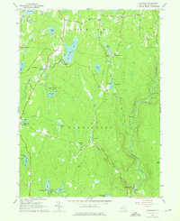
1966 Map of Hartwood
USGS Topo · Published 1976About this map
The Neversink River carves through the eastern portion of this Sullivan County landscape, featuring notable landmarks like High Falls and Denton Falls. This mid-century survey reveals a transition from natural water bodies to managed recreation and conservation, exemplified by the Fish Hatchery and numerous private enclaves like Merriewold Park and the Hartwood Club. The interior is dotted with significant water features including St Josephs Lake, Burnt Hope Lake, and Crane Pond, many of which supported the early 20th-century resort culture of the region.
Find a feature on this map
52 named features on this map. Tap any name to fly to it.
Don’t see what you’re looking for? This feature index may not catch every label — zoom into the map to look around manually.
Map Details
Editions of this 1966 Hartwood Map
2 editions found
Other maps of this area

1906 · Port Jervis
USGS Topo · 1:62,500

1908 · Port Jervis
USGS Topo · 1:62,500

1909 · Monticello
USGS Topo · 1:62,500

1911 · Monticello
USGS Topo · 1:62,500

1913 · Milford
USGS Topo · 1:62,500

1915 · Milford
USGS Topo · 1:62,500

1922 · White Lake
USGS Topo · 1:62,500

1942 · White Lake
USGS Topo · 1:62,500

1942 · Port Jervis North
USGS Topo · 1:24,000
1942 · Otisville
USGS Topo · 1:24,000