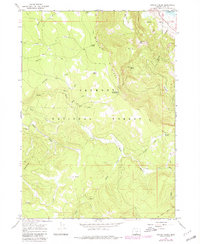
1966 Map of Harvey Creek
USGS Topo · Published 1980About this map
Winter Ridge dominates this high-country landscape in Lake County, where the Fremont National Forest preserves a rugged network of water sources and early access routes. The map is defined by the prominent Old Indian Treaty Boundary cutting across the terrain, reflecting the historical division of land rights in the region. This 1960s survey, updated in 1980, shows a remote wilderness largely devoid of permanent settlements, focused instead on seasonal land use. Historical points of interest include Skull Creek Camp and Government Harvey Pass, while numerous water sources like Harvey Spring, Currier Spring, and Boulder Spring indicate the importance of these sites for both wildlife and early travelers. The upper reaches of the Sycan River and the Hanan Trail provide a look at the early infrastructure of this high-plateau environment.
Find a feature on this map
30 named features on this map. Tap any name to fly to it.
Don’t see what you’re looking for? This feature index may not catch every label — zoom into the map to look around manually.
Map Details
Editions of this 1966 Harvey Creek Map
2 editions found
Other maps of this area

1955 · Klamath Falls
USGS Topo · 1:250,000

1958 · Klamath Falls
USGS Topo · 1:250,000

1966 · Shake Butte
USGS Topo · 1:24,000

1966 · Slide Mtn
USGS Topo · 1:24,000

1966 · Sandhill Crossing
USGS Topo · 1:24,000

1966 · Harvey Creek
USGS Topo · 1:24,000

1966 · Fremont Point
USGS Topo · 1:24,000

1966 · Coffeepot Creek
USGS Topo · 1:24,000

1966 · Pole Butte
USGS Topo · 1:24,000

1966 · Lee Thomas Crossing
USGS Topo · 1:24,000