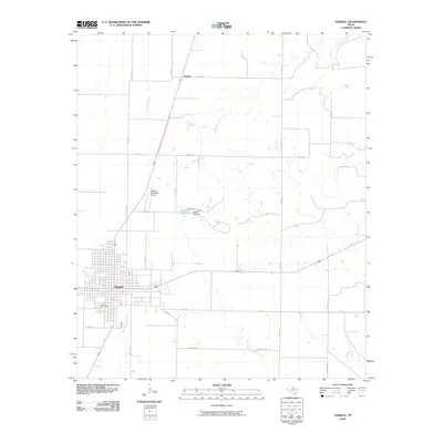
2010 Map of Haskell
USGS Topo · Published 2010About this map
The city of Haskell serves as the hub of this West Texas landscape, defined by its rectilinear grid and an extensive network of rural roads such as Jim Strain Rd and Wheatley Rd. To the west of the main town site, the Willow Cemetery provides a primary point of interest for genealogists, while the Haskell Municipal Airport anchors the town's northern approach. The surrounding countryside is primarily agricultural, bisected by several drainage systems including Rice Springs Branch, Millers Creek, and Buffalo Creek. A distinct focal point is found at Country Club Lake, created by the Haskell Club Dam, which offers a localized break from the surrounding plains. To the north, the small settlement area of Josselet appears along the intersection of Co RD 223 and Co RD 222, illustrating the characteristic spacing of farming communities in Haskell County during this period.
Find a feature on this map
31 named features on this map. Tap any name to fly to it.
Don’t see what you’re looking for? This feature index may not catch every label — zoom into the map to look around manually.
Map Details
Editions of this 2010 Haskell Map
This is the sole edition of this map. No revisions or reprints were ever made.
Other maps of this area

1954 · Wichita Falls
USGS Topo · 1:250,000

1958 · Wichita Falls
USGS Topo · 1:250,000

1966 · Haskell
USGS Topo · 1:24,000
1966 · Lake Stamford East
USGS Topo · 1:24,000
1966 · Dudleys Creek
USGS Topo · 1:24,000
1966 · Pinkerton
USGS Topo · 1:24,000
1966 · Lake Stamford West
USGS Topo · 1:24,000
1966 · Irby
USGS Topo · 1:24,000

1967 · Rochester
USGS Topo · 1:24,000

1967 · Weinert
USGS Topo · 1:24,000