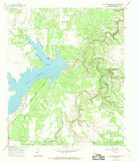
1966 Map of Lake Stamford East
USGS Topo · Published 1969About this map
Lake Stamford dominates this mid-1960s survey of Haskell County, serving as a focal point for both local recreation and utility infrastructure. The reservoir is marked by the Stamford Corporate Boundary and features lakeside amenities like Scott Memorial Park and multiple Picnic Areas. The landscape is defined by the winding paths of Paint Creek, Horse Creek, and California Creek, which carve through the terrain before meeting the lake. This era shows the active management of water resources in West Texas, evidenced by the presence of a Powerplant, a Pumping Sta, and an Aqueduct. Petroleum exploration is also visible through numerous scattered Drill Holes and an Oil Well located in the northwest. Local transportation is highlighted by landmarks such as Scott Crossing, providing a specific look at the rural connectivity of the region before further modern development.
Find a feature on this map
17 named features on this map. Tap any name to fly to it.
Don’t see what you’re looking for? This feature index may not catch every label — zoom into the map to look around manually.
Map Details
Editions of this 1966 Lake Stamford East Map
2 editions found
Other maps of this area

1891 · Anson
USGS Topo · 1:125,000

1892 · Albany
USGS Topo · 1:125,000

1893 · Albany
USGS Topo · 1:125,000

1893 · Anson
USGS Topo · 1:125,000

1954 · Abilene
USGS Topo · 1:250,000

1954 · Wichita Falls
USGS Topo · 1:250,000

1958 · Wichita Falls
USGS Topo · 1:250,000

1958 · Abilene
USGS Topo · 1:250,000

1965 · Lueders NW
USGS Topo · 1:24,000

1965 · Lueders NE
USGS Topo · 1:24,000