
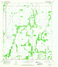
1965 Map of Lueders NW
USGS Topo · Published 1967About this map
California Creek winds through this West Texas landscape along the border of Haskell and Jones counties, anchoring a rural environment defined by mid-century ranching and resource extraction. The map documents the infrastructure of a working agrarian economy, from the Cotton Gin south of Dodge to the Gravel Pit and Oil Field operations scattered across the plains.
Find a feature on this map
20 named features on this map. Tap any name to fly to it.
Don’t see what you’re looking for? This feature index may not catch every label — zoom into the map to look around manually.
Map Details
Editions of this 1965 Lueders NW Map
This is the sole edition of this map. No revisions or reprints were ever made.
Other maps of this area

1891 · Anson
USGS Topo · 1:125,000

1893 · Anson
USGS Topo · 1:125,000

1954 · Abilene
USGS Topo · 1:250,000

1954 · Wichita Falls
USGS Topo · 1:250,000

1958 · Wichita Falls
USGS Topo · 1:250,000

1958 · Abilene
USGS Topo · 1:250,000

1965 · Lueders NE
USGS Topo · 1:24,000

1965 · Lueders West
USGS Topo · 1:24,000

1965 · Lueders East
USGS Topo · 1:24,000
1965 · Funston
USGS Topo · 1:24,000