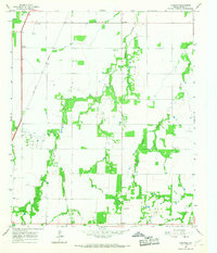
1965 Map of Funston
USGS Topo · Published 1967About this map
Corinth and New Hope anchor this 1960s landscape in Jones County, where the agricultural plains are deeply etched by a network of drainage creeks. The Fort Worth and Denver railroad cuts a straight line through the western portion of the map, serving the small communities and rural outposts like Funston. Much of the map's character is defined by the wandering paths of Redmud Creek and Harmony Creek, which create pockets of brush and vegetation that contrast with the organized grid of cultivated fields and fence lines.
Find a feature on this map
23 named features on this map. Tap any name to fly to it.
Don’t see what you’re looking for? This feature index may not catch every label — zoom into the map to look around manually.
Map Details
Editions of this 1965 Funston Map
This is the sole edition of this map. No revisions or reprints were ever made.
Other maps of this area

1891 · Anson
USGS Topo · 1:125,000

1893 · Anson
USGS Topo · 1:125,000

1954 · Abilene
USGS Topo · 1:250,000

1957 · Hawley
USGS Topo · 1:62,500

1957 · Nugent
USGS Topo · 1:62,500

1958 · Abilene
USGS Topo · 1:250,000

1965 · Tuxedo
USGS Topo · 1:24,000

1965 · Lueders NW
USGS Topo · 1:24,000

1965 · Lueders West
USGS Topo · 1:24,000
1965 · Stamford
USGS Topo · 1:24,000