
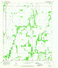
1965 Map of Lueders West
USGS Topo · Published 1967About this map
The Clear Fork Brazos River anchors the southeastern corner of this Jones County landscape, where the town of Lueders sits at the intersection of river, rail, and industry. In the mid-1960s, the local economy is defined by a mix of ranching and natural resource extraction, evident in the numerous Quarries and extensive Oil Field operations scattered throughout the territory. The Missouri - Kansas - Texas railroad cuts a diagonal path across the quadrangle, linking the community of Avoca in the northwest to the wider regional trade network.
Find a feature on this map
19 named features on this map. Tap any name to fly to it.
Don’t see what you’re looking for? This feature index may not catch every label — zoom into the map to look around manually.
Map Details
Editions of this 1965 Lueders West Map
This is the sole edition of this map. No revisions or reprints were ever made.
Other maps of this area

1891 · Anson
USGS Topo · 1:125,000

1893 · Anson
USGS Topo · 1:125,000

1954 · Abilene
USGS Topo · 1:250,000

1957 · Hawley
USGS Topo · 1:62,500

1957 · Nugent
USGS Topo · 1:62,500

1958 · Abilene
USGS Topo · 1:250,000

1965 · Lueders NW
USGS Topo · 1:24,000

1965 · Lueders NE
USGS Topo · 1:24,000

1965 · Lueders East
USGS Topo · 1:24,000
1965 · Funston
USGS Topo · 1:24,000