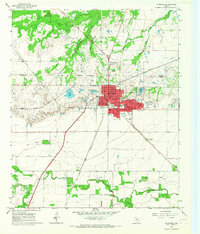
1965 Map of Stamford
USGS Topo · Published 1967About this map
Stamford sits at a geographic and administrative crossroads, straddling the Haskell Co Jones Co boundary in West Texas. The mid-1960s layout reveals a community centered on agricultural and rail commerce, where the Fort Worth and Denver and Missouri Kansas Texas railroads converge. This transit hub is anchored by several neighborhood institutions, including the Washington Sch and St Anns Ch, while the Texas Cowboy Reunion Grounds on the western edge of town speaks to the area's deep ranching heritage.
Find a feature on this map
49 named features on this map. Tap any name to fly to it.
Don’t see what you’re looking for? This feature index may not catch every label — zoom into the map to look around manually.
Map Details
Editions of this 1965 Stamford Map
This is the sole edition of this map. No revisions or reprints were ever made.
Other maps of this area

1891 · Anson
USGS Topo · 1:125,000

1893 · Anson
USGS Topo · 1:125,000

1954 · Abilene
USGS Topo · 1:250,000

1954 · Wichita Falls
USGS Topo · 1:250,000

1958 · Wichita Falls
USGS Topo · 1:250,000

1958 · Abilene
USGS Topo · 1:250,000

1964 · Sagerton
USGS Topo · 1:24,000

1965 · Tuxedo
USGS Topo · 1:24,000

1965 · Lueders NW
USGS Topo · 1:24,000

1965 · Lueders West
USGS Topo · 1:24,000