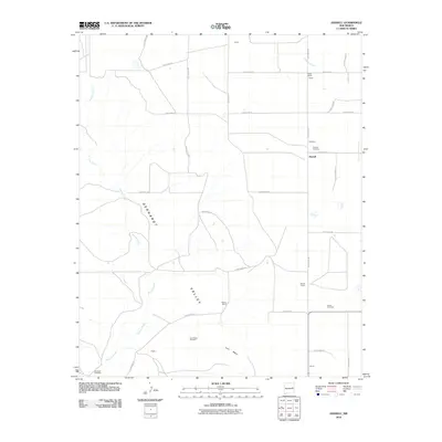
2010 Map of Hassell
USGS Topo · Published 2010About this map
Gerhardt Valley and the prominent Lone Mesa define the ranching landscape of Quay County in this 2010 survey. The settlement of Hassell serves as a central point in a grid of rural routes, including Quay Road 31 and Quay Road BH. This map is particularly valuable for genealogical research, as it identifies several isolated burial grounds such as Gerhardt Cemetery, Hassell Cemetery, House Cemetery, and Lone Mesa Cemetery. The drainage patterns of Truchas Creek and Alamosa Creek cut through the terrain, illustrating the water sources essential for local operations like Parmer Ranch, Urton Ranch, and Ballew Ranch. Smaller named locales including Upton, Lewis, Shiply, and Bomar are also documented, providing a precise record of late 20th-century land use and habitation in this part of eastern New Mexico.
Find a feature on this map
32 named features on this map. Tap any name to fly to it.
Don’t see what you’re looking for? This feature index may not catch every label — zoom into the map to look around manually.
Map Details
Editions of this 2010 Hassell Map
This is the sole edition of this map. No revisions or reprints were ever made.
Other maps of this area

1954 · Fort Sumner
USGS Topo · 1:250,000

1954 · Clovis
USGS Topo · 1:250,000

1958 · Fort Sumner
USGS Topo · 1:250,000

1958 · Clovis
USGS Topo · 1:250,000

1968 · Hassell
USGS Topo · 1:24,000

1968 · Twin Mesa NW
USGS Topo · 1:24,000

1968 · Ima SE
USGS Topo · 1:24,000

1968 · Candy Mesa
USGS Topo · 1:24,000

1968 · Twin Mesa
USGS Topo · 1:24,000
1968 · Ima SW
USGS Topo · 1:24,000