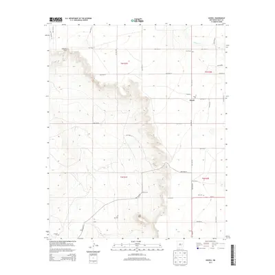
2013 Map of Hassell
USGS Topo · Published 2013About this map
Hassell and its surrounding ranchlands occupy a landscape defined by dramatic mesa breaks and the winding paths of Alamosa Cr and Truchas Cr. This 2013 survey reveals a rural settlement pattern deeply connected to family-named landholdings and isolated community points. Prominent geographic markers like Lone Mesa and the sweeping Gerhardt Valley frame the region, while the presence of scattered cemeteries such as Hassell Cem, Lone Mesa Cem, and Gerhardt Cem provides essential touchpoints for genealogical research. The network of Quay County roads and NM-252 connects local landmarks including Urton Ranch, Parmer Ranch, and Ballew Ranch, reflecting the enduring agricultural character of the high plains. The map also documents smaller named locales like Shiply, Upton, and Bomar, preserving the specific nomenclature of this eastern New Mexico territory.
Find a feature on this map
40 named features on this map. Tap any name to fly to it.
Don’t see what you’re looking for? This feature index may not catch every label — zoom into the map to look around manually.
Map Details
Editions of this 2013 Hassell Map
This is the sole edition of this map. No revisions or reprints were ever made.
Other maps of this area

1954 · Fort Sumner
USGS Topo · 1:250,000

1954 · Clovis
USGS Topo · 1:250,000

1958 · Fort Sumner
USGS Topo · 1:250,000

1958 · Clovis
USGS Topo · 1:250,000

1968 · Hassell
USGS Topo · 1:24,000

1968 · Twin Mesa NW
USGS Topo · 1:24,000

1968 · Ima SE
USGS Topo · 1:24,000

1968 · Candy Mesa
USGS Topo · 1:24,000

1968 · Twin Mesa
USGS Topo · 1:24,000
1968 · Ima SW
USGS Topo · 1:24,000