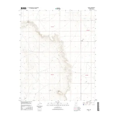
2017 Map of Hassell
USGS Topo · Published 2017About this map
Hassell sits on the high plains of Quay County, defined by a dramatic escarpment that separates the flat eastern terrain from the lower Gerhardt Valley to the west. This landscape is marked by the rugged descent from Lone Mesa, where the headwaters of Truchas Cr and Alamosa Cr begin to carve through the mesa edge. The map captures a quiet ranching and farming district, where the settlement pattern is sparse and oriented around a network of rural roads like Q R 31. Genealogy researchers will find several small burial sites preserved on this 2017 survey, including Hassell Cem, House Cem, Lone Mesa Cem, and Gerhardt Cem, which serve as lasting markers of the families who settled this corner of New Mexico.
Find a feature on this map
21 named features on this map. Tap any name to fly to it.
Don’t see what you’re looking for? This feature index may not catch every label — zoom into the map to look around manually.
Map Details
Editions of this 2017 Hassell Map
This is the sole edition of this map. No revisions or reprints were ever made.
Other maps of this area

1954 · Fort Sumner
USGS Topo · 1:250,000

1954 · Clovis
USGS Topo · 1:250,000

1958 · Fort Sumner
USGS Topo · 1:250,000

1958 · Clovis
USGS Topo · 1:250,000

1968 · Hassell
USGS Topo · 1:24,000

1968 · Twin Mesa NW
USGS Topo · 1:24,000

1968 · Ima SE
USGS Topo · 1:24,000

1968 · Candy Mesa
USGS Topo · 1:24,000

1968 · Twin Mesa
USGS Topo · 1:24,000
1968 · Ima SW
USGS Topo · 1:24,000