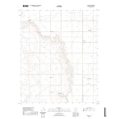
2020 Map of Hassell
USGS Topo · Published 2020About this map
Gerhardt Valley and the prominent rising terrain of Lone Mesa define this high-plains landscape in Quay County. The settlement of Hassell sits at a crossroads in the northeast, serving as a focal point for the surrounding ranching and agricultural lands. The geography is deeply tied to its watercourses, notably Alamosa Cr and the winding Truchas Cr, which carve through the terrain as it shifts between the valley floor and elevated mesa tops. Genealogy and local history are preserved through several scattered burial sites, including Hassell Cem, House Cem, and the Lone Mesa Cem, which indicate the dispersed nature of early 20th-century homesteading. A network of rural routes, such as QR BH and QR 33, connects these remote sites across the township lines of the Public Land Survey System.
Find a feature on this map
24 named features on this map. Tap any name to fly to it.
Don’t see what you’re looking for? This feature index may not catch every label — zoom into the map to look around manually.
Map Details
Editions of this 2020 Hassell Map
This is the sole edition of this map. No revisions or reprints were ever made.
Other maps of this area

1954 · Fort Sumner
USGS Topo · 1:250,000

1954 · Clovis
USGS Topo · 1:250,000

1958 · Fort Sumner
USGS Topo · 1:250,000

1958 · Clovis
USGS Topo · 1:250,000

1968 · Hassell
USGS Topo · 1:24,000

1968 · Twin Mesa NW
USGS Topo · 1:24,000

1968 · Ima SE
USGS Topo · 1:24,000

1968 · Candy Mesa
USGS Topo · 1:24,000

1968 · Twin Mesa
USGS Topo · 1:24,000
1968 · Ima SW
USGS Topo · 1:24,000