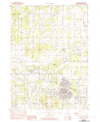
1982 Map of Hastings
USGS Topo · Published 1982About this map
The Thornapple River winds through the heart of this Barry County landscape, anchoring the city of Hastings as it appeared in the early 1980s. The city is a dense network of civic and community infrastructure, featuring a concentration of education and healthcare facilities including Pennock Hosp, Central Sch, and Jr High Sch. Beyond the urban core, the terrain is defined by a series of kettle lakes and glacial depressions, most notably Algonquin Lake, Leach Lake, and Bear Hole Lake.
Find a feature on this map
62 named features on this map. Tap any name to fly to it.
Don’t see what you’re looking for? This feature index may not catch every label — zoom into the map to look around manually.
Map Details
Editions of this 1982 Hastings Map
This is the sole edition of this map. No revisions or reprints were ever made.
Other maps of this area

1916 · Ionia
USGS Topo · 1:62,500

1918 · Ionia
USGS Topo · 1:62,500

1918 · Lowell
USGS Topo · 1:62,500

1943 · Ionia
USGS Topo · 1:62,500

1943 · Lowell
USGS Topo · 1:62,500

1950 · Nashville
USGS Topo · 1:62,500

1951 · Nashville
USGS Topo · 1:62,500

1951 · Hastings
USGS Topo · 1:62,500

1958 · Grand Rapids
USGS Topo · 1:250,000

1961 · Grand Rapids
USGS Topo · 1:250,000