
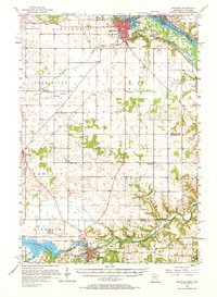
1957 Map of Hastings
USGS Topo · Published 1959About this map
Hastings serves as the focal point for this mid-century look at the confluence of the Mississippi River and Vermillion River. The landscape reflects a mix of heavy infrastructure and rural institutional history, featuring the expansive State Hospital and Mineral Springs Sanatorium south of the city center. This era captures the dense network of the Chicago Milwaukee St Paul and Pacific RR and the Chicago Great Western as they moved freight through the river valleys.
Find a feature on this map
42 named features on this map. Tap any name to fly to it.
Don’t see what you’re looking for? This feature index may not catch every label — zoom into the map to look around manually.
Map Details
Editions of this 1957 Hastings Map
2 editions found
Other maps of this area

1896 · St. Paul
USGS Topo · 1:62,500

1944 · Red Wing
USGS Topo · 1:62,500

1946 · Hudson
USGS Topo · 1:62,500

1946 · River Falls
USGS Topo · 1:62,500

1949 · River Falls
USGS Topo · 1:62,500

1949 · Hudson
USGS Topo · 1:62,500

1950 · St Paul Park
USGS Topo · 1:24,000

1951 · St Paul Park
USGS Topo · 1:24,000

1951 · Prescott
USGS Topo · 1:24,000

1951 · Inver Grove
USGS Topo · 1:24,000