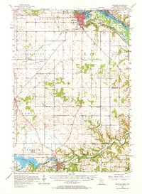
1957 Map of Hastings
USGS Topo · Published 1967About this map
The Mississippi River creates a natural boundary between Minnesota and Wisconsin in the north, while the Cannon Falls area anchors the southern landscape. In the mid-1950s, this region was characterized by small agricultural settlements and specialized healthcare facilities like the Mineral Springs Sanatorium and the State Hospital near Hastings. The rail network of the Chicago Great Western and the Chicago Milwaukee St Paul and Pacific lines connected these rural communities, facilitating the transport of goods and passengers between towns like Hampton and New Trier. Water management is prominent in the south, where the Wood Dam controls the Byllesby Reservoir on the Cannon River. Numerous gravel pits and a quarry suggest a local economy tied to natural resource extraction and construction during a period of steady Midwestern growth.
Find a feature on this map
49 named features on this map. Tap any name to fly to it.
Don’t see what you’re looking for? This feature index may not catch every label — zoom into the map to look around manually.
Map Details
Editions of this 1957 Hastings Map
2 editions found

Other maps of this area

1896 · St. Paul
USGS Topo · 1:62,500

1944 · Red Wing
USGS Topo · 1:62,500

1946 · Hudson
USGS Topo · 1:62,500

1946 · River Falls
USGS Topo · 1:62,500

1949 · River Falls
USGS Topo · 1:62,500

1949 · Hudson
USGS Topo · 1:62,500

1950 · St Paul Park
USGS Topo · 1:24,000

1951 · St Paul Park
USGS Topo · 1:24,000

1951 · Prescott
USGS Topo · 1:24,000

1951 · Inver Grove
USGS Topo · 1:24,000