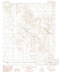
1986 Map of Hat Mountain SW
USGS Topo · Published 1986About this map
The Sauceda Mountains dominate this 1986 survey of the Arizona desert, where the peaks and ridges define a landscape dedicated largely to military activity. The entire region is encompassed by the Luke Air Force Range, a massive tract of land used for training and defense operations. The map details the complex topography of the range, including the winding path of Ryans Canyon and numerous unnamed washes that drain the high ground. Along the western edge, the small location of Midway marks a point of human presence near the Maricopa Co and Pima Co line. The Military Reservation Boundary is clearly delineated, illustrating the division between the restricted range and the surrounding desert lands.
Find a feature on this map
8 named features on this map. Tap any name to fly to it.
Don’t see what you’re looking for? This feature index may not catch every label — zoom into the map to look around manually.
Map Details
Editions of this 1986 Hat Mountain SW Map
This is the sole edition of this map. No revisions or reprints were ever made.
Other maps of this area

1932 · Ajo
USGS Topo · 1:62,500

1934 · Ajo
USGS Topo · 1:62,500

1953 · Ajo
USGS Topo · 1:250,000

1957 · Ajo
USGS Topo · 1:250,000

1958 · Ajo
USGS Topo · 1:250,000

1958 · Midway
USGS Topo · 1:62,500

1958 · Hat Mountain
USGS Topo · 1:62,500

1962 · Ajo
USGS Topo · 1:250,000

1963 · Ajo
USGS Topo · 1:250,000

1963 · Ajo
USGS Topo · 1:62,500