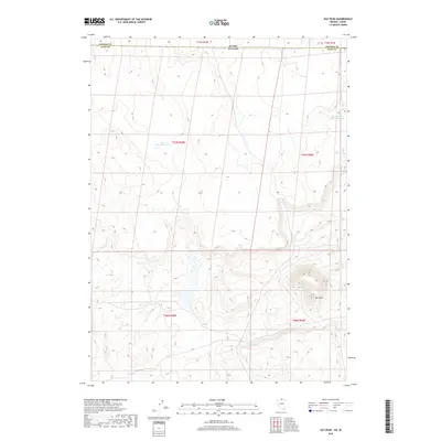
2018 Map of Hat Peak
USGS Topo · Published 2018About this map
Hat Peak rises above the high desert floor at the edge of Elko County, defining the topographic character of this remote borderland where Nevada meets Idaho. This survey reflects a landscape shaped by water management and grazing in an arid environment, where isolated landmarks like Garat Reservoir 610 and Reservation Fence Reservoir serve as critical points of reference. The boundary between Elko Co and Owyhee Co spans the northern reach of the map, marking the transition into Idaho. A scattering of seasonal water sources such as Butte Spring provides the few natural breaks in the vast open terrain, highlighting the sparse but essential network of springs and reservoirs used by local ranchers in the early 21st century.
Find a feature on this map
12 named features on this map. Tap any name to fly to it.
Don’t see what you’re looking for? This feature index may not catch every label — zoom into the map to look around manually.
Map Details
Editions of this 2018 Hat Peak Map
This is the sole edition of this map. No revisions or reprints were ever made.
Other maps of this area

1955 · McDermitt
USGS Topo · 1:250,000

1955 · Jordan Valley
USGS Topo · 1:250,000

1957 · Jordan Valley
USGS Topo · 1:250,000

1958 · Jordan Valley
USGS Topo · 1:250,000

1959 · McDermitt
USGS Topo · 1:250,000

1964 · Hat Peak
USGS Topo · 1:62,500

1971 · Juniper Basin SE
USGS Topo · 1:24,000

1971 · Juniper Basin
USGS Topo · 1:24,000
1973 · Four Corners
USGS Topo · 1:24,000
1974 · Twelvemile Flat SE
USGS Topo · 1:24,000