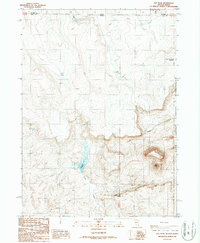
1987 Map of Hat Peak
USGS Topo · Published 1987About this map
The Duck Valley Indian Reservation occupies the eastern edge of this high-desert landscape along the Idaho and Nevada border. Centered on the prominent landmark of Hat Peak, the terrain is defined by the winding course of Circle Creek and several critical water sources including Josephine Reservoir and Reservation Fence Reservoir. This 1987 provisional map captures a remote section of Elko County as it appeared in the late twentieth century, showing a network of unimproved routes such as Bob Johnson Road and Johnson Road that served the local ranching and tribal lands. The presence of Butte Spring and other scattered water points illustrates the vital role of natural springs in supporting life and livestock across these arid rangelands. This survey provides a clear view of the state boundary between Idaho and Nevada, where Owyhee and Elko counties meet.
Find a feature on this map
15 named features on this map. Tap any name to fly to it.
Don’t see what you’re looking for? This feature index may not catch every label — zoom into the map to look around manually.
Map Details
Editions of this 1987 Hat Peak Map
This is the sole edition of this map. No revisions or reprints were ever made.
Other maps of this area

1955 · McDermitt
USGS Topo · 1:250,000

1955 · Jordan Valley
USGS Topo · 1:250,000

1957 · Jordan Valley
USGS Topo · 1:250,000

1958 · Jordan Valley
USGS Topo · 1:250,000

1959 · McDermitt
USGS Topo · 1:250,000

1964 · Hat Peak
USGS Topo · 1:62,500

1971 · Juniper Basin SE
USGS Topo · 1:24,000

1971 · Juniper Basin
USGS Topo · 1:24,000
1973 · Four Corners
USGS Topo · 1:24,000
1974 · Twelvemile Flat SE
USGS Topo · 1:24,000