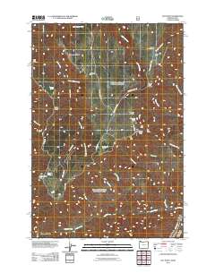
2011 Map of Hat Point
USGS Topo · Published 2011About this map
The Snake River defines the southeastern corner of this high-elevation terrain, where deep drainage systems like Lightning Creek and Horse Creek carve through the landscape. This 2011 survey illustrates the infrastructure of the U.S. Forest Service in the Hells Canyon vicinity, including the Hat Point Lookout Tower and the remote Horse Creek Cabin. Navigation across the high ridges is facilitated by the Snake River View Rd and Hat Point Rd, which lead to critical vantage points such as Granny View Point and the Horse Creek Viewpoint. Smaller landmarks like Sacajawea Spring and Hoodoo Spring provide rare water sources along the steep slopes of Grizzly Ridge and Summit Ridge. The presence of the Memaloose Airstrip and Warnock Corral highlights the area's history as a working landscape for both aviation and ranching within the national forest.
Find a feature on this map
38 named features on this map. Tap any name to fly to it.
Don’t see what you’re looking for? This feature index may not catch every label — zoom into the map to look around manually.
Map Details
Editions of this 2011 Hat Point Map
This is the sole edition of this map. No revisions or reprints were ever made.
Other maps of this area

1922 · He Devil
USGS Topo · 1:48,000

1954 · Imnaha
USGS Topo · 1:62,500

1954 · Kernan Point
USGS Topo · 1:62,500

1954 · Harl Butte
USGS Topo · 1:62,500

1955 · Grangeville
USGS Topo · 1:250,000

1957 · He Devil
USGS Topo · 1:62,500

1959 · Grangeville
USGS Topo · 1:250,000

1980 · Grangeville
USGS Topo · 1:100,000

1987 · Riggins
USGS Topo · 1:100,000

1990 · Imnaha
USGS Topo · 1:24,000