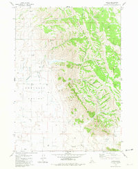
1981 Map of Hatch
USGS Topo · Published 1981About this map
Hatch serves as the primary focal point of this Caribou County landscape, situated on the western edge of the Chesterfield Range. The geography here is defined by the transition between the high ridges and the broad agricultural stretches of the Portneuf Valley and Gem Valley. Resource management and grain transport appear central to the local economy, evidenced by infrastructure like the Grain Elevator and various Storage Bins. The map meticulously tracks water resources in an arid environment, noting several Well sites and unnamed Spring locations alongside named drainages such as Eighteenmile Creek and Tenmile Creek. Notable family-named landforms including Higginson Canyon and Tolman Canyon cut through the hills, while Tenmile Pass provides a transition southward toward the Soda Springs Hills.
Find a feature on this map
24 named features on this map. Tap any name to fly to it.
Don’t see what you’re looking for? This feature index may not catch every label — zoom into the map to look around manually.
Map Details
Editions of this 1981 Hatch Map
This is the sole edition of this map. No revisions or reprints were ever made.
Other maps of this area

1914 · Henry
USGS Topo · 1:48,000

1916 · Henry
USGS Topo · 1:62,500

1917 · Portneuf
USGS Topo · 1:62,500

1948 · Bancroft
USGS Topo · 1:62,500

1948 · Soda Springs
USGS Topo · 1:62,500

1949 · Bancroft
USGS Topo · 1:62,500

1949 · Soda Springs
USGS Topo · 1:62,500

1955 · Preston
USGS Topo · 1:250,000

1958 · Preston
USGS Topo · 1:250,000

1962 · Preston
USGS Topo · 1:250,000