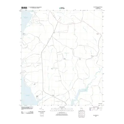
2011 Map of Hatcher
USGS Topo · Published 2011About this map
The Chattahoochee River corridor along the Georgia-Alabama border defines this landscape, where the expansive Walter F George Reservoir meets a network of inland creeks and family-named landmarks. The terrain is deeply etched by water, with Drag Nasty Creek, Wilkey Creek, and Pataula Creek draining toward the reservoir. Local history is anchored by several rural burial grounds, including the Old Pataula Cemetery and Methvin Cemetery, which serve as vital markers for genealogical research in this part of Quitman County.
Find a feature on this map
65 named features on this map. Tap any name to fly to it.
Don’t see what you’re looking for? This feature index may not catch every label — zoom into the map to look around manually.
Map Details
Editions of this 2011 Hatcher Map
This is the sole edition of this map. No revisions or reprints were ever made.
Other maps of this area

1953 · Dothan
USGS Topo · 1:250,000

1954 · Dothan
USGS Topo · 1:250,000

1955 · Dothan
USGS Topo · 1:250,000

1967 · Hatcher
USGS Topo · 1:24,000

1967 · Georgetown
USGS Topo · 1:24,000

1968 · Eufaula North
USGS Topo · 1:24,000

1968 · Eufaula South
USGS Topo · 1:24,000

1969 · Fort Gaines NW
USGS Topo · 1:24,000

1969 · Fort Gaines NE
USGS Topo · 1:24,000
1972 · Sanford
USGS Topo · 1:24,000