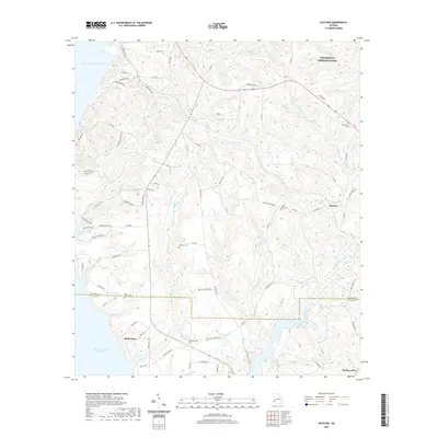
2020 Map of Hatcher
USGS Topo · Published 2020About this map
Walter F George Reservoir defines the western edge of this landscape, where the waters of the Chattahoochee River system meet the varied terrain of the Georgia-Alabama border. The inland area is a network of creek drainages including Drag Nasty Creek, Pataula Creek, and Wildcat Creek, which carve through the elevations of Georgetown-Quitman County. Small settlements like Hatcher and Garnersville are connected by a web of local routes and county roads, reflecting the rural character of the region.
Find a feature on this map
82 named features on this map. Tap any name to fly to it.
Don’t see what you’re looking for? This feature index may not catch every label — zoom into the map to look around manually.
Map Details
Editions of this 2020 Hatcher Map
This is the sole edition of this map. No revisions or reprints were ever made.
Other maps of this area

1953 · Dothan
USGS Topo · 1:250,000

1954 · Dothan
USGS Topo · 1:250,000

1955 · Dothan
USGS Topo · 1:250,000

1967 · Hatcher
USGS Topo · 1:24,000

1967 · Georgetown
USGS Topo · 1:24,000

1968 · Eufaula North
USGS Topo · 1:24,000

1968 · Eufaula South
USGS Topo · 1:24,000

1969 · Fort Gaines NW
USGS Topo · 1:24,000

1969 · Fort Gaines NE
USGS Topo · 1:24,000
1972 · Sanford
USGS Topo · 1:24,000