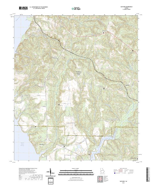
2024 Map of Hatcher
USGS Topo · Published 2024About this map
Pataula Creek and its many tributaries, including Wilkey Creek and Billy Methvin Creek, define the landscape of this southern Georgia survey. The region is characterized by small, dispersed settlements like Hatcher and Garnersville, connected by a network of rural routes such as Co Rd 29 and Taylors Store Rd. Cultural and genealogical history is deeply embedded in the land, marked by numerous small cemeteries and places of worship. Features such as the Shady Grove African Methodist Episcopal Church Cem and Mt Zion Church Cem serve as focal points for local heritage. To the west, the reach of the Walter F George Reservoir shapes the terrain, while the boundary between Quitman and Clay Counties cuts across the southern portion of the map, illustrating the administrative divisions of this largely agricultural and wooded riverine environment.
Find a feature on this map
83 named features on this map. Tap any name to fly to it.
Don’t see what you’re looking for? This feature index may not catch every label — zoom into the map to look around manually.
Map Details
Editions of this 2024 Hatcher Map
This is the sole edition of this map. No revisions or reprints were ever made.
Other maps of this area

1953 · Dothan
USGS Topo · 1:250,000

1954 · Dothan
USGS Topo · 1:250,000

1955 · Dothan
USGS Topo · 1:250,000

1967 · Hatcher
USGS Topo · 1:24,000

1967 · Georgetown
USGS Topo · 1:24,000

1968 · Eufaula North
USGS Topo · 1:24,000

1968 · Eufaula South
USGS Topo · 1:24,000

1969 · Fort Gaines NW
USGS Topo · 1:24,000

1969 · Fort Gaines NE
USGS Topo · 1:24,000
1972 · Sanford
USGS Topo · 1:24,000