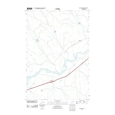
2011 Map of Hathaway
USGS Topo · Published 2011About this map
The Yellowstone River cuts a wide, braided path through this Rosebud County landscape, anchoring the small communities of Hathaway and Sheffield. The settlement at Hathaway is closely tied to the transport corridor formed by Old Hwy 10-12, where the Hathaway Post Office and nearby Hathaway Cemetery serve as primary local landmarks. The northern reaches are defined by a network of drainage systems, including Wilson Creek and Whitetail Creek, which are managed by several specific water control structures like Hook Number 2 Dam and Hook Number 67 Dam.
Find a feature on this map
20 named features on this map. Tap any name to fly to it.
Don’t see what you’re looking for? This feature index may not catch every label — zoom into the map to look around manually.
Map Details
Editions of this 2011 Hathaway Map
This is the sole edition of this map. No revisions or reprints were ever made.
Other maps of this area

1954 · Forsyth
USGS Topo · 1:250,000

1957 · Forsyth
USGS Topo · 1:250,000

1958 · Forsyth
USGS Topo · 1:250,000

1968 · Sand Buttes
USGS Topo · 1:24,000

1968 · Hathaway
USGS Topo · 1:24,000

1968 · Butterfly Creek
USGS Topo · 1:24,000

1968 · Horton
USGS Topo · 1:24,000

1968 · Hathaway NW
USGS Topo · 1:24,000

1968 · Thurlow
USGS Topo · 1:24,000
1969 · Moon Creek School
USGS Topo · 1:24,000