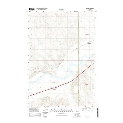
2014 Map of Hathaway
USGS Topo · Published 2014About this map
The Yellowstone River carves a broad valley through the eastern Montana landscape of Rosebud and Custer counties, anchoring the small settlements of Hathaway and Sheffield. This 2014 survey reveals a transition between the irrigated lowlands near the river and the dissected coulees of the surrounding uplands. Local history and genealogy are centered around the Hathaway Cem south of the main town site, located near the intersection of several local drainages. The map records a complex network of seasonal watercourses, including Graveyard Cr, Wilson Cr, and Iron Jaw Cr, which feed into the river system. Transportation is defined by the proximity of Highway 446 and the rural route of Creek Rd, reflecting the agricultural and ranching infrastructure that has defined this stretch of the Yellowstone valley for generations.
Find a feature on this map
21 named features on this map. Tap any name to fly to it.
Don’t see what you’re looking for? This feature index may not catch every label — zoom into the map to look around manually.
Map Details
Editions of this 2014 Hathaway Map
This is the sole edition of this map. No revisions or reprints were ever made.
Other maps of this area

1954 · Forsyth
USGS Topo · 1:250,000

1957 · Forsyth
USGS Topo · 1:250,000

1958 · Forsyth
USGS Topo · 1:250,000

1968 · Sand Buttes
USGS Topo · 1:24,000

1968 · Hathaway
USGS Topo · 1:24,000

1968 · Butterfly Creek
USGS Topo · 1:24,000

1968 · Horton
USGS Topo · 1:24,000

1968 · Hathaway NW
USGS Topo · 1:24,000

1968 · Thurlow
USGS Topo · 1:24,000
1969 · Moon Creek School
USGS Topo · 1:24,000