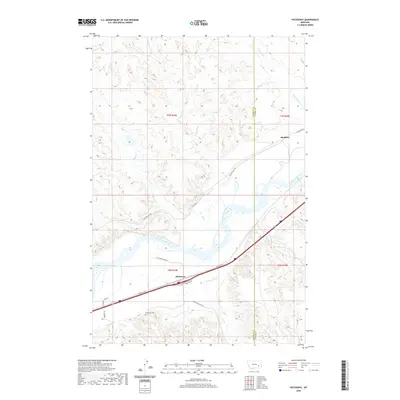
2020 Map of Hathaway
USGS Topo · Published 2020About this map
The Yellowstone River bisects this landscape, shaping the development of the small settlements of Hathaway and Sheffield along its banks. The terrain is defined by a dense network of coulees and drainage creeks, including Wilson Creek, Bull Creek, and Whitetail Cr, which flow through the dissected uplands of Rosebud and Custer Counties. This 2020 record illustrates the enduring imprint of ranching and rural transit, where named local routes like Calamity Jane Ln, Tombstone Rd, and Hathaway Ranch Ln suggest a storied Western history. For those tracing family roots in this corner of Montana, the Hathaway Cem stands as a primary genealogical landmark south of the primary transportation corridor. The map details the interface between the fertile river valley and the arid, broken ridges that characterize the regional topography.
Find a feature on this map
27 named features on this map. Tap any name to fly to it.
Don’t see what you’re looking for? This feature index may not catch every label — zoom into the map to look around manually.
Map Details
Editions of this 2020 Hathaway Map
This is the sole edition of this map. No revisions or reprints were ever made.
Other maps of this area

1954 · Forsyth
USGS Topo · 1:250,000

1957 · Forsyth
USGS Topo · 1:250,000

1958 · Forsyth
USGS Topo · 1:250,000

1968 · Sand Buttes
USGS Topo · 1:24,000

1968 · Hathaway
USGS Topo · 1:24,000

1968 · Butterfly Creek
USGS Topo · 1:24,000

1968 · Horton
USGS Topo · 1:24,000

1968 · Hathaway NW
USGS Topo · 1:24,000

1968 · Thurlow
USGS Topo · 1:24,000
1969 · Moon Creek School
USGS Topo · 1:24,000