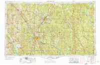
1953 Map of Hattiesburg
USGS Topo · Published 1976About this map
The Hattiesburg hub anchors this mid-century look at the Pine Belt region, where the Leaf River and Bowie River converge. At this time, the landscape is defined by the heavy timber of the De Soto National Forest and the industrial activity of Laurel. The map illustrates a dense transportation network of established railroads like the Illinois Central and Gulf Mobile & Ohio, which served timber and agricultural interests across the Mississippi-Alabama border.
Find a feature on this map
79 named features on this map. Tap any name to fly to it.
Don’t see what you’re looking for? This feature index may not catch every label — zoom into the map to look around manually.
Map Details
Editions of this 1953 Hattiesburg Map
4 editions found

Other maps of this area

1903 · Jackson
USGS Topo · 1:125,000

1906 · Florence
USGS Topo · 1:62,500

1908 · Florence
USGS Topo · 1:62,500

1935 · White Oak
USGS Topo · 1:24,000

1941 · Bay Minette
USGS Topo · 1:62,500

1941 · Creola
USGS Topo · 1:62,500

1941 · Lucedale
USGS Topo · 1:62,500

1942 · Thomas
USGS Topo · 1:31,680

1942 · Deer Park
USGS Topo · 1:62,500

1942 · Wilmer
USGS Topo · 1:62,500