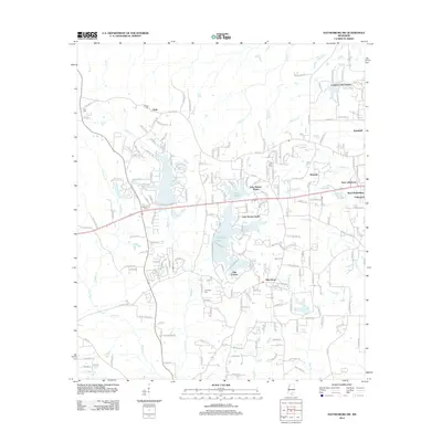
2012 Map of Hattiesburg SW
USGS Topo · Published 2012About this map
Hennington Lake and Lake Serene South anchor the center of this landscape, illustrating the residential development patterns that expanded west of the primary city center. The map documents a blend of established rural communities and newer subdivisions, where the topography is defined by the winding paths of Perkins Creek and Mixons Creek. The presence of numerous family and community burial grounds, such as Rawls Cemetery, Bellvue Cemetery, and Grantham Cemetery, provides a vital spatial record for genealogists tracking local family histories in Forrest County. Further north, the settlement of Clyde sits along Old Hwy 42, while the transition toward suburban living is evident in neighborhoods like Country Club Estates and Oak Forrest. The hydrography is particularly detailed, tracing the headwaters of Black Creek and Little Black Creek as they move through the southern portion of the quadrangle.
Find a feature on this map
197 named features on this map. Tap any name to fly to it.
Don’t see what you’re looking for? This feature index may not catch every label — zoom into the map to look around manually.
Map Details
Editions of this 2012 Hattiesburg SW Map
This is the sole edition of this map. No revisions or reprints were ever made.
Other maps of this area

1953 · Hattiesburg
USGS Topo · 1:250,000

1958 · Hattiesburg
USGS Topo · 1:250,000

1964 · Purvis
USGS Topo · 1:24,000

1964 · Hattiesburg
USGS Topo · 1:24,000

1965 · Hattiesburg SW
USGS Topo · 1:24,000

1965 · Dixie
USGS Topo · 1:24,000

1965 · Eastabuchie
USGS Topo · 1:24,000

1965 · Sanford
USGS Topo · 1:24,000

1969 · Baxterville NE
USGS Topo · 1:24,000

1974 · Sumrall
USGS Topo · 1:24,000