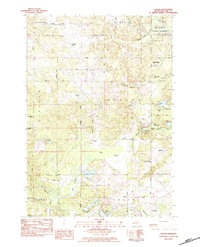
1983 Map of Hatton
USGS Topo · Published 1984About this map
The Middle Branch Tobacco River winds through the heart of this central Michigan landscape, where the settlements of Hatton and Brown Corners serve as local anchors. The map reveals a transition from the dense woodlands of the Au Sable State Forest in the northeast to the low-lying terrain of the Bear Swamp and the waters of Loon Lake. The era is defined by the development of local education and recreation, highlighted by the campus of Mid-Michigan Community College and the nearby Clare-Gladwin Sch. Recreational pursuits are prominent in the local economy, evidenced by the Snow Snake Mtn Ski Area, Major Mtn Ski Club, and Camp Rotary. Genealogists will find the Township Cem and Andersen Chapel particularly useful for tracing family ties in this part of Clare County.
Find a feature on this map
53 named features on this map. Tap any name to fly to it.
Don’t see what you’re looking for? This feature index may not catch every label — zoom into the map to look around manually.
Map Details
Editions of this 1983 Hatton Map
This is the sole edition of this map. No revisions or reprints were ever made.
Other maps of this area

1954 · Traverse City
USGS Topo · 1:250,000

1954 · Midland
USGS Topo · 1:250,000

1957 · Harrison
USGS Topo · 1:62,500

1958 · Traverse City
USGS Topo · 1:250,000

1958 · Midland
USGS Topo · 1:250,000

1959 · Midland
USGS Topo · 1:250,000

1959 · Clare
USGS Topo · 1:62,500

1966 · Midland
USGS Topo · 1:250,000

1969 · Meredith SW
USGS Topo · 1:24,000
1969 · Browns Corners
USGS Topo · 1:24,000