
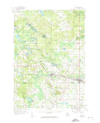
1959 Map of Clare
USGS Topo · Published 1960About this map
The Clare and Farwell areas of central Michigan are defined by a complex intersection of rail and water in the late 1950s. The Chesapeake and Ohio and Ann Arbor Railroad cross south of the Tobacco River, serving as the industrial backbone for these growing settlements near the Clare and Isabella County line. The northern landscape is heavily dominated by the Houghton Lake State Forest, where numerous glacial lakes such as Lake George and Shingle Lake are interspersed with low-lying areas like Deadman Swamp and Bear Swamp. Local life is anchored by country institutions including the Maple Grove Ch, the Township Cem near Hatton, and rural schoolhouses like Redner Sch and Wilson Sch. Notable landmarks include the McKay Landing Field and the Camp Rotary grounds, illustrating the region's mix of aviation and recreational land use.
Find a feature on this map
99 named features on this map. Tap any name to fly to it.
Don’t see what you’re looking for? This feature index may not catch every label — zoom into the map to look around manually.
Map Details
Editions of this 1959 Clare Map
2 editions found
Other maps of this area

1916 · Mount Pleasant
USGS Topo · 1:62,500

1919 · Mount Pleasant
USGS Topo · 1:62,500

1930 · Shepherd
USGS Topo · 1:48,000

1936 · Shepherd
USGS Topo · 1:62,500

1943 · Mount Pleasant
USGS Topo · 1:62,500

1954 · Traverse City
USGS Topo · 1:250,000

1954 · Midland
USGS Topo · 1:250,000

1957 · Harrison
USGS Topo · 1:62,500

1957 · Marion
USGS Topo · 1:62,500

1958 · Traverse City
USGS Topo · 1:250,000