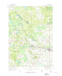
1959 Map of Clare
USGS Topo · Published 1960About this map
The city of Clare serves as a central hub in this late-1950s survey, where the Ann Arbor Railroad and the Chesapeake and Ohio lines intersect. This junction, combined with the presence of the Middle Br Tobacco R, highlights the area's history as a transportation and logging corridor. To the west, the village of Farwell is situated near the Surrey Cem, while the northern reaches are dominated by the extensive Houghton Lake State Forest and a high density of glacial lakes including Lake George and Windover Lake. Local education and community life are marked by rural landmarks such as the Maple Grove Ch, Redner Sch, and Old Townline Cem. The terrain is further defined by the Bear Swamp and numerous small water bodies like Lily Lake and Bertha Lake, illustrating the varied wetlands of central Michigan.
Find a feature on this map
97 named features on this map. Tap any name to fly to it.
Don’t see what you’re looking for? This feature index may not catch every label — zoom into the map to look around manually.
Map Details
Editions of this 1959 Clare Map
2 editions found

Other maps of this area

1916 · Mount Pleasant
USGS Topo · 1:62,500

1919 · Mount Pleasant
USGS Topo · 1:62,500

1930 · Shepherd
USGS Topo · 1:48,000

1936 · Shepherd
USGS Topo · 1:62,500

1943 · Mount Pleasant
USGS Topo · 1:62,500

1954 · Traverse City
USGS Topo · 1:250,000

1954 · Midland
USGS Topo · 1:250,000

1957 · Harrison
USGS Topo · 1:62,500

1957 · Marion
USGS Topo · 1:62,500

1958 · Traverse City
USGS Topo · 1:250,000