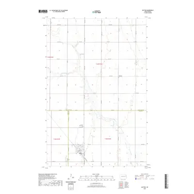
2020 Map of Hatton
USGS Topo · Published 2020About this map
The agricultural town of Hatton sits in the southwestern portion of this Red River Valley landscape, where the local street grid is defined by thoroughfares like Wheat Ave and Dakota Ave S. The town's proximity to the rail line is marked by Railroad Ave E, reflecting the critical role of transport in this North Dakota farming community. North of the town center, the N Br Goose River meanders across the prairie, its path occasionally interrupted by rural section roads such as Old Hwy 15 and Co Rd 25. This survey highlights the local legacy through several burial grounds, including the Carl Ben Eielson Cem and the Zion Lutheran Cem, which are significant for family history researchers looking to locate ancestral sites in Traill and Steele Counties.
Find a feature on this map
44 named features on this map. Tap any name to fly to it.
Don’t see what you’re looking for? This feature index may not catch every label — zoom into the map to look around manually.
Map Details
Editions of this 2020 Hatton Map
This is the sole edition of this map. No revisions or reprints were ever made.
Other maps of this area

1934 · Emerado
USGS Topo · 1:48,000

1936 · Emerado
USGS Topo · 1:62,500

1936 · Larimore
USGS Topo · 1:62,500

1952 · Grand Forks
USGS Topo · 1:250,000

1956 · Grand Forks
USGS Topo · 1:250,000

1963 · Kempton
USGS Topo · 1:24,000

1963 · Emerado SE
USGS Topo · 1:24,000

1963 · Emerado SW
USGS Topo · 1:24,000

1966 · Grand Forks
USGS Topo · 1:250,000
1970 · Northwood SE
USGS Topo · 1:24,000