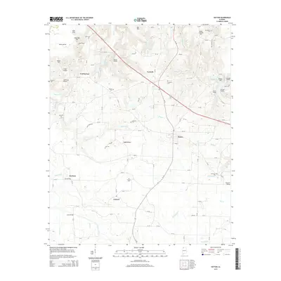
2014 Map of Hatton
USGS Topo · Published 2014About this map
Hatton and the surrounding Lawrence County uplands are defined by a complex network of creeks and family-named hollows as they appeared in 2014. The landscape is dotted with small settlements like Wolf Springs, Oak Grove, and Concord, connected by a grid of county roads and the primary artery of AL-157. Genealogists will find a high density of rural burial grounds, including the Roden Cem, Love Cem, and Fergason Cem, many of which sit near the headwaters of local drainages like Masterson Cr and Watches Cr. The geography transitions from the higher elevations of Mill Mtn and Black Ground Mtn in the north toward the flatter expanses of the Moulton Valley in the southeast. Historical crossings are well-documented, with named structures such as Harris Bridge over Town Creek and Lackey Bridge over Pool Cr providing specific points of reference for local history research.
Find a feature on this map
112 named features on this map. Tap any name to fly to it.
Don’t see what you’re looking for? This feature index may not catch every label — zoom into the map to look around manually.
Map Details
Editions of this 2014 Hatton Map
This is the sole edition of this map. No revisions or reprints were ever made.
Other maps of this area

1924 · Tuscumbia
USGS Topo · 1:48,000

1926 · Tuscumbia
USGS Topo · 1:62,500

1935 · Moulton
USGS Topo · 1:24,000

1936 · Newburg
USGS Topo · 1:24,000

1936 · Courtland
USGS Topo · 1:24,000

1936 · Moulton
USGS Topo · 1:48,000

1936 · Town Creek
USGS Topo · 1:24,000
1936 · Leighton
USGS Topo · 1:24,000

1936 · Masterson
USGS Topo · 1:24,000

1936 · Hatton
USGS Topo · 1:24,000