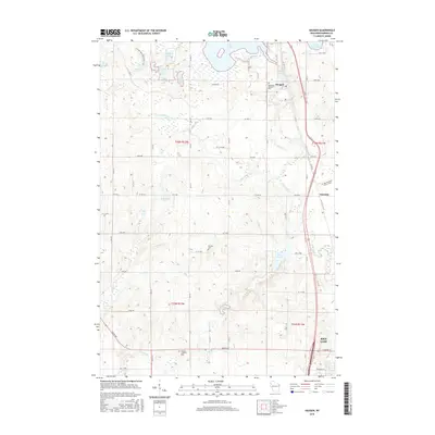
2015 Map of Haugen
USGS Topo · Published 2015About this map
Glacial topography and a dense network of inland lakes define this Barron County landscape, where the Ice Age National Scenic Trail winds through the eastern hills. The village of Haugen serves as a northern anchor, situated near the shores of Bear Lake and the Bohemian National Cem. To the south, the expansion of Rice Lake begins to appear, connected to the surrounding countryside by a grid of numbered avenues and county highways. The map reveals a land shaped by both its geology and its immigrant heritage, evidenced by sites like the Stanfold Lutheran Cem and Wiesner Cem. Water is the dominant feature, from the secluded Lake Desair and Ginder Lake to the meandering paths of Little Bear Cr and Hickey Cr. The presence of the Tuscobia settlement along the eastern corridor highlights the historical transit routes that once linked these lakeside communities.
Find a feature on this map
67 named features on this map. Tap any name to fly to it.
Don’t see what you’re looking for? This feature index may not catch every label — zoom into the map to look around manually.
Map Details
Editions of this 2015 Haugen Map
This is the sole edition of this map. No revisions or reprints were ever made.
Other maps of this area

1949 · Rice Lake
USGS Topo · 1:48,000

1951 · Shell Lake
USGS Topo · 1:48,000

1951 · Rice Lake
USGS Topo · 1:48,000

1951 · Chetek
USGS Topo · 1:62,500

1951 · Barron
USGS Topo · 1:62,500

1953 · Rice Lake
USGS Topo · 1:250,000

1959 · Rice Lake
USGS Topo · 1:250,000

1965 · Rice Lake
USGS Topo · 1:62,500

1965 · Shell Lake
USGS Topo · 1:62,500
1978 · Poskin
USGS Topo · 1:24,000