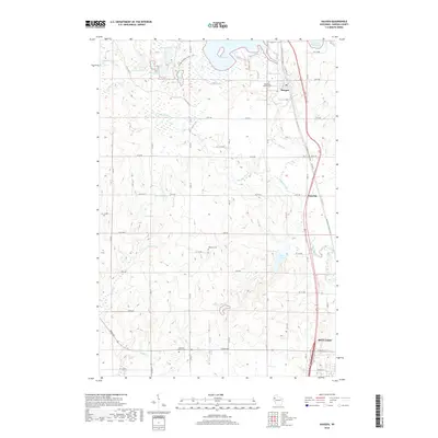
2018 Map of Haugen
USGS Topo · Published 2018About this map
Bear Lake dominates the northern landscape of this Barron County region, where the village of Haugen serves as a primary local hub. The area is characterized by an intricate network of kettle lakes and wetlands, including Lake Desair, Ginder Lake, and Fish Lake, which are interconnected by drainages like Bear Creek and Little Bear Creek. For researchers, the map reveals a quiet rural layout defined by a grid of numbered avenues and streets that navigate the varied terrain around Tuscobia. Cultural history is anchored by several small burial grounds, notably the Bohemian National Cemetery and Wiesner Cemetery. Modern recreation and conservation are represented by the crossing of the Ice Age National Scenic Trail and the Wild Rivers State Trail, highlighting the area's continued role as a gateway to the Wisconsin lake country north of Rice Lake.
Find a feature on this map
66 named features on this map. Tap any name to fly to it.
Don’t see what you’re looking for? This feature index may not catch every label — zoom into the map to look around manually.
Map Details
Editions of this 2018 Haugen Map
This is the sole edition of this map. No revisions or reprints were ever made.
Other maps of this area

1949 · Rice Lake
USGS Topo · 1:48,000

1951 · Shell Lake
USGS Topo · 1:48,000

1951 · Rice Lake
USGS Topo · 1:48,000

1951 · Chetek
USGS Topo · 1:62,500

1951 · Barron
USGS Topo · 1:62,500

1953 · Rice Lake
USGS Topo · 1:250,000

1959 · Rice Lake
USGS Topo · 1:250,000

1965 · Rice Lake
USGS Topo · 1:62,500

1965 · Shell Lake
USGS Topo · 1:62,500
1978 · Poskin
USGS Topo · 1:24,000