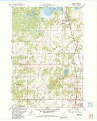
1982 Map of Haugen
USGS Topo · Published 1982About this map
The Chicago and North Western railroad corridor anchors this survey of northern Barron County, defining the industrial and transit spine through Haugen and down toward Tuscobia. The landscape is a complex network of glacial water bodies and wetlands, including the expansive Bear Lake and smaller basins like Ginder Lake, Lake Desair, and Mitchell Lake. The conversion of old rail infrastructure is already evident with the appearance of the Tuscobia Park Falls State Trail branching off the main line. Local heritage and community landmarks are scattered throughout the rural sections, from the Stanfold Church in the south to the Wiesner Cemetery. Conservation efforts are well-established by this era, marked by the Hickey Creek State Public Fishery Area and Engle Creek Springs State Public Fishery Area, which protect the cold-water streams feeding the region's larger lakes.
Find a feature on this map
34 named features on this map. Tap any name to fly to it.
Don’t see what you’re looking for? This feature index may not catch every label — zoom into the map to look around manually.
Map Details
Editions of this 1982 Haugen Map
This is the sole edition of this map. No revisions or reprints were ever made.
Other maps of this area

1949 · Rice Lake
USGS Topo · 1:48,000

1951 · Shell Lake
USGS Topo · 1:48,000

1951 · Rice Lake
USGS Topo · 1:48,000

1951 · Chetek
USGS Topo · 1:62,500

1951 · Barron
USGS Topo · 1:62,500

1953 · Rice Lake
USGS Topo · 1:250,000

1959 · Rice Lake
USGS Topo · 1:250,000

1965 · Rice Lake
USGS Topo · 1:62,500

1965 · Shell Lake
USGS Topo · 1:62,500
1978 · Poskin
USGS Topo · 1:24,000