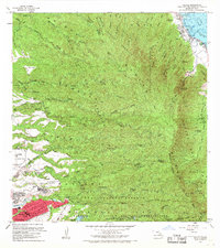
1966 Map of Hauula
USGS Topo · Published 1968About this map
Koolau Range crests dominate the interior of Oahu in this mid-1960s survey, illustrating a landscape defined by deep gulches and significant military and forest reserves. The windward coast is anchored by Hauula, while the leeward side reveals the development of Wahiawa and the Wahiawa Homesteads. Notable for local history and genealogy are the presence of Our Lady of Sorrows Sch and Leilehua High Sch, along with the Helemano Radio Station and the US Naval Reservation.
Find a feature on this map
57 named features on this map. Tap any name to fly to it.
Don’t see what you’re looking for? This feature index may not catch every label — zoom into the map to look around manually.
Map Details
Editions of this 1966 Hauula Map
This is the sole edition of this map. No revisions or reprints were ever made.
Other maps of this area

1952 · Waimea
USGS Topo · 1:24,000

1953 · Haleiwa
USGS Topo · 1:24,000

1953 · Schofield Barracks
USGS Topo · 1:24,000

1953 · Hauula
USGS Topo · 1:24,000

1954 · Oahu
USGS Topo · 1:250,000

1954 · Kahuku
USGS Topo · 1:24,000

1954 · Kahana
USGS Topo · 1:24,000

1954 · Kaneohe
USGS Topo · 1:24,000

1954 · Waipahu
USGS Topo · 1:24,000

1959 · Kaneohe
USGS Topo · 1:24,000