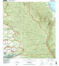
1992 Map of Hauula
USGS Topo · Published 2001About this map
The windward and central landscapes of Oahu are dominated by the sharp ridges of the Ko'Olau Range in this detailed study of the island's interior and shoreline. Along the coast, the community of Hau'ula sits along the Kamehameha Hwy, where local landmarks like the Hau'ula Sch and numerous stream outlets like Kokololio Stream meet the Pacific Ocean. The interior is defined by massive tracts of restricted land, including the Kawailoa (Military Training Reservation) and the Kahuku Training Area (Military Reservation), showcasing the significant military presence on the island during the late twentieth century.
Find a feature on this map
38 named features on this map. Tap any name to fly to it.
Don’t see what you’re looking for? This feature index may not catch every label — zoom into the map to look around manually.
Map Details
Editions of this 1992 Hauula Map
This is the sole edition of this map. No revisions or reprints were ever made.
Other maps of this area

1952 · Waimea
USGS Topo · 1:24,000

1953 · Haleiwa
USGS Topo · 1:24,000

1953 · Schofield Barracks
USGS Topo · 1:24,000

1953 · Hauula
USGS Topo · 1:24,000

1954 · Oahu
USGS Topo · 1:250,000

1954 · Kahuku
USGS Topo · 1:24,000

1954 · Kahana
USGS Topo · 1:24,000

1954 · Kaneohe
USGS Topo · 1:24,000

1954 · Waipahu
USGS Topo · 1:24,000

1959 · Kaneohe
USGS Topo · 1:24,000