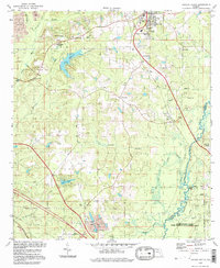
1994 Map of Havana South
USGS Topo · Published 1998About this map
Havana anchors the northern reaches of this Florida panhandle landscape, which transitions from settled communities to the expansive wetlands of the Ochlockonee River State Wildlife Management Area. The map reveals a tapestry of small settlements and local landmarks, including Scotland and Gibson, connected by rural routes such as Lanier Road. Genealogists will find numerous family and community burial sites, from the Nicholson-Freeman Cem near Salem to the Ferrell Cem located further south near Midway.
Find a feature on this map
51 named features on this map. Tap any name to fly to it.
Don’t see what you’re looking for? This feature index may not catch every label — zoom into the map to look around manually.
Map Details
Editions of this 1994 Havana South Map
This is the sole edition of this map. No revisions or reprints were ever made.
Other maps of this area

1940 · Tallahassee
USGS Topo · 1:62,500

1942 · Tallahassee
USGS Topo · 1:62,500

1943 · Tallahassee
USGS Topo · 1:62,500

1943 · Lake Talquin
USGS Topo · 1:62,500

1954 · Tallahassee
USGS Topo · 1:250,000

1956 · Havana North
USGS Topo · 1:24,000

1956 · Dogtown
USGS Topo · 1:24,000

1956 · Calvary
USGS Topo · 1:24,000

1959 · Tallahassee
USGS Topo · 1:250,000

1959 · Quincy
USGS Topo · 1:24,000