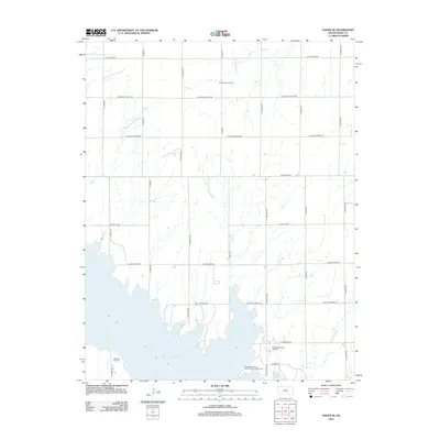
2012 Map of Haven SE
USGS Topo · Published 2012About this map
Cheney Reservoir dominates the southern landscape of this Reno County region, marking a significant hydrological shift in the Kansas terrain. Along its northern shores, the Cheney State Park Wichita Point Campground serves as a modern recreation anchor, while older echoes of the area's pioneer heritage remain at Pleasant Hill Cem near S Yoder Rd. The map also illustrates the region's long-standing reliance on subterranean resources, with the Friendship Gas Field and Hilger Southwest Oil Field indicating active mineral extraction amidst the rural grid. Drainage through the agricultural sections is defined by Gar Cr and Rock Cr, which feed into the primary reservoir basin. This landscape is bound by a systematic road network, including thoroughfares like E Pretty Prairie Rd and S Haven Rd, connecting the scattered farmsteads and energy production sites.
Find a feature on this map
23 named features on this map. Tap any name to fly to it.
Don’t see what you’re looking for? This feature index may not catch every label — zoom into the map to look around manually.
Map Details
Editions of this 2012 Haven SE Map
This is the sole edition of this map. No revisions or reprints were ever made.
Other maps of this area

1889 · Cheney
USGS Topo · 1:125,000

1891 · Cheney
USGS Topo · 1:125,000

1901 · Cheney
USGS Topo · 1:125,000

1955 · Wichita
USGS Topo · 1:250,000

1958 · Wichita
USGS Topo · 1:250,000

1958 · Patterson
USGS Topo · 1:24,000

1959 · Mount Hope
USGS Topo · 1:24,000
1961 · Haven
USGS Topo · 1:24,000
1961 · Elmer
USGS Topo · 1:24,000

1964 · Cheney
USGS Topo · 1:24,000