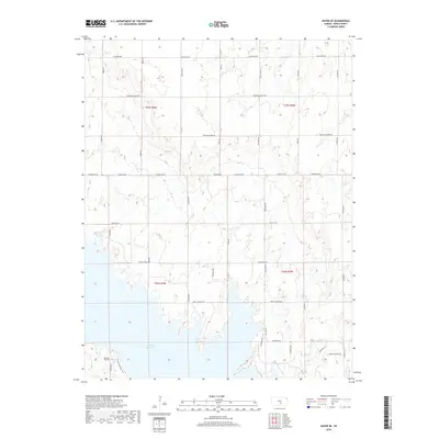
2018 Map of Haven SE
USGS Topo · Published 2018About this map
The expansive waters of Cheney Reservoir dominate the southwestern corner of this landscape in Reno County, where the plains of Kansas meet significant water management infrastructure. This 2018 survey documents a region defined by a precise section-line road grid, including family-named and descriptive thoroughfares like Fountain Green Rd, Silver Lake Rd, and Johns Oil Rd. The reservoir's irregular shoreline contrasts with the rigid township lines of t25s r5w and t25s r4w, illustrating the intersection of natural topography and legal land divisions.
Find a feature on this map
29 named features on this map. Tap any name to fly to it.
Don’t see what you’re looking for? This feature index may not catch every label — zoom into the map to look around manually.
Map Details
Editions of this 2018 Haven SE Map
This is the sole edition of this map. No revisions or reprints were ever made.
Other maps of this area

1889 · Cheney
USGS Topo · 1:125,000

1891 · Cheney
USGS Topo · 1:125,000

1901 · Cheney
USGS Topo · 1:125,000

1955 · Wichita
USGS Topo · 1:250,000

1958 · Wichita
USGS Topo · 1:250,000

1958 · Patterson
USGS Topo · 1:24,000

1959 · Mount Hope
USGS Topo · 1:24,000
1961 · Haven
USGS Topo · 1:24,000
1961 · Elmer
USGS Topo · 1:24,000

1964 · Cheney
USGS Topo · 1:24,000