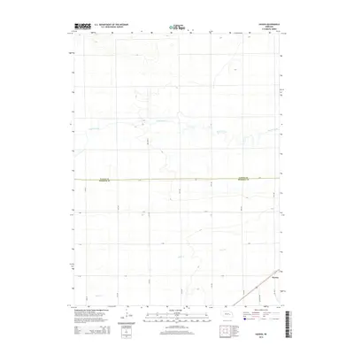
2014 Map of Havens
USGS Topo · Published 2014About this map
Havens stands as a quiet focal point in a landscape defined by the agricultural grid of Merrick and Nance Counties. The terrain is marked by the slow, meandering courses of Prairie Creek and Silver Cr, which cut through the level plains and influence the local road network. This 2014 survey captures a moment in the modern rural economy where established county lines like Nance Co and Merrick Co intersect with a precise system of section roads. The map provides a clear record for those tracing local landmarks along Half Mile Rd and S 340th Ave, reflecting the enduring structure of Nebraska’s central farmlands where water and roadway orientation remain the primary geographic features.
Find a feature on this map
17 named features on this map. Tap any name to fly to it.
Don’t see what you’re looking for? This feature index may not catch every label — zoom into the map to look around manually.
Map Details
Editions of this 2014 Havens Map
This is the sole edition of this map. No revisions or reprints were ever made.
Other maps of this area

1896 · Stromsburg
USGS Topo · 1:125,000

1955 · Fremont
USGS Topo · 1:250,000

1957 · Fremont
USGS Topo · 1:250,000

1958 · Fremont
USGS Topo · 1:250,000

1958 · Genoa
USGS Topo · 1:24,000
1958 · Merchiston
USGS Topo · 1:24,000

1958 · Fullerton
USGS Topo · 1:24,000

1958 · Fullerton NE
USGS Topo · 1:24,000

1958 · Silver Creek
USGS Topo · 1:24,000

1958 · Havens
USGS Topo · 1:24,000