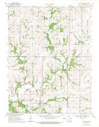
1969 Map of Havensville
USGS Topo · Published 1971About this map
Havensville serves as the primary hub in this late 1960s landscape, situated at the intersection of local routes and the Old Railroad Grade. The topography is defined by the winding paths of Vermillion Creek, Spring Creek, and Wolf Creek, which carve through the townships of Grant, Soldier, and Red Vermillion. This survey captures a moment of transition where the historical rail infrastructure was being superseded by a subterranean Pipeline cutting across the eastern sections. Local social and family history is anchored by the Greenwood Community Club and several rural burial sites, including Havensville Cem, America City Cem, and Rose Hill Cem. The presence of a Gravel Pit and Quarry near the Nemaha and Jackson County line indicates the ongoing importance of local mineral extraction to the area's rural economy during this period.
Find a feature on this map
20 named features on this map. Tap any name to fly to it.
Don’t see what you’re looking for? This feature index may not catch every label — zoom into the map to look around manually.
Map Details
Editions of this 1969 Havensville Map
This is the sole edition of this map. No revisions or reprints were ever made.
Other maps of this area

1888 · Hiawatha
USGS Topo · 1:125,000

1889 · Seneca
USGS Topo · 1:125,000

1889 · Wamego
USGS Topo · 1:125,000

1889 · Topeka
USGS Topo · 1:125,000

1894 · Seneca
USGS Topo · 1:125,000

1894 · Topeka
USGS Topo · 1:125,000

1894 · Hiawatha
USGS Topo · 1:125,000

1894 · Wamego
USGS Topo · 1:125,000

1950 · Kansas City
USGS Topo · 1:250,000

1954 · Kansas City
USGS Topo · 1:250,000